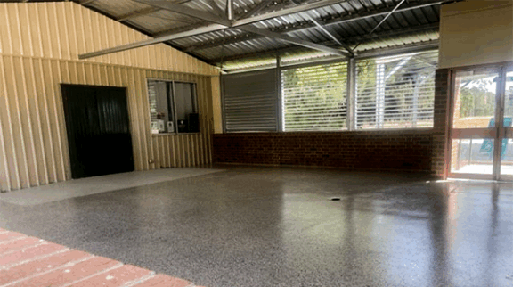
Site Map


    About Harvey
    Local Towns
    Cookernup

    Map - Cookernup

    The area of land known today as the locality of Cookernup was first traversed by white men in 1835, Stephen Henty and Thomas Peel being guided through the reaches of the Harvey River by aborigines.

    The first settler, Joseph Logue, came to the area in 1852 with his mother, brothers and sisters, in search for good farming land, acquiring a grant of 9,000 acres, and two years later leasing 23,000 acres of the Darling Range foothills. He then purchased land on the northern bank of a brook, which became known as Logue Brook.

    In 1856 he married Sarah Davies, by whom he had seven children. Their homestead was called "Convolvulus Villa" (the mail coach stopped at Logues in the 1860's on its way to Bunbury.) In his later years Joseph became a Government Sheep Inspector and was killed near Geraldton in 1888 while carrying out his duty.

    Williams Mill tram ran down to Weekes' Siding (south of Cookernup) and Ferguson Mill's tram rail ran alongside Riverdale Road conveying timber to Cookernup. The trucks used on the tram rails had no engine but were operated by one man using a handbrake as the trucks accelerated down the hills. After the timber was unloaded a horse team hauled the trucks back up the hill to the mill. There was a railway reserve north of Cookernup for timber stacking; this was opposite "Homebush Farm"

    (Shire of Harvey 1895-1995: Proud to be 100 p.14)

    Print Friendly

    Shire Updates
    14 Aug 2008
    Public Notice Of Council Meetings
    14 Aug 2008
    Four O'clock Reports Available Here
    02 Aug 2008
    Community Safety And Crime Prevention Survey
    Shire Events

    No Events found.

    ADMIN
    Copyright ©2005
    All rights reserved.

    Content, images, comments and links published on this site
    are in no way endorsed by Connect South West Association Inc.

    This site provided by
    mysouthwest.com.au